Barky Faces Death
I have traveled all over the country. I’ve hiked in forests and mountains and brush and swamps and beaches. I almost always hike alone, therefore I have to be very well prepared. I plan my trips carefully, carry the right gear, dress for the weather (current and potential), and stick to the trails. I’ve seen too many idiots hiking in flip-flops, and read too many stories of people getting lost in blizzards. There are many ways I may end up leaving this world, but dying in the wilderness due to unpreparedness, that’s not for me.

At least, that’s what I used to think.
My trip to Arizona was the first time I took two consecutive weeks’ vacation and visited multiple park sites on a grand tour. I was excited, of course. Arizona would be great. It has the most NPS sites of any state in the country and, best of all, it has deserts! One of the great joys in touring this country is walking terrains one normally doesn’t see. New England is known for rolling hills, deciduous forests, urban jungles, and snow. There are no deserts in New England, and there probably won’t be any in our lifetimes, unless we initiate a global apocalypse or something. My trip to Arizona would be the first time I’ve ever walked in a desert.
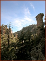
After weeks of planning, I landed in Tucson, checked into the hotel, and hit the sack. First on the list for the AM: Chiricahua National Monument, home of fantastic rocky spires, eons worth of erosional glory. I had plenty of water, salty snacks, light clothing, sunscreen, wide-brimmed hat, good shoes, and a dogged determination that I would walk at an uncharacteristically gentle pace, fully in line with the challenges of the environment. I hit the Echo Canyon loop trail (only 3.1 miles long, much shorter than my normal day hikes, again being cognizant of the heat) with great excitement.
 After less than a mile on the trail (the downhill leg no doubt), I thought I’d die.
Something was seriously wrong. I was drinking enough water. I was pacing myself. I was just exhausted! I had never felt so bad walking on a trail in my life. I had to stop every 100′ and catch a breather. Nearly every step was a chore. I finally hit a point of near-panic when the thought hit my head: beautiful scenery be damned, I was going to die on this very trail. Here, thousands of miles from home, far away from family and friends, a stranger in a strange land, I was going to die. At least the next hiker would find me, perhaps my sunburnt corpse would be saved from the buzzards.
It was at that very moment that I heard the sound, a sound that I’ve only heard on television and in the movies …
Some time ago, I heard this theory: “There are two ways to hear a rattlesnake. If you hear it and see the tail, you have a story to tell your friends. If you hear it and see the head, no one will ever hear your story.”
As you have undoubtedly guessed, I spotted the tail. It was about a foot from my left shoe, darting into some low shrubbery.
 I think most people would have panicked. For some odd reason, I found this comforting. If my time was up, it would have been the head of that rattlesnake, not the tail, and I would be dead. I was not going to die that day, I was convinced of that. All that was left was getting my head back into the game and focus my attention on getting out of the bad situation.
Slowly I continued my way up the trail. Fortunately, the way back up was shady. It was still trouble going but, eventually, I plodded my way back to the rental car and headed to the hotel. A foot-long Subway sub and a gallon of water later, I hit the sack and slept 13 hours straight. I felt great the next morning, and headed to Fort Bowie, Saguaro, and all of the rest of the parks in Arizona without incident over the next two weeks.
It wasn’t until much, much later that it came to me. I live in Connecticut, mean altitude a whopping 500′ above sea level. Altitude at the entrance of the Echo Canyon Trail? 6,780 feet! Oof, no wonder I almost collapsed & died amidst the rocky spires of Chiricahua!
Nowadays, when I travel to high-altitude areas, I always take at least a full day to acclimate before taking to the trails. Fortunately, I’ve lived long enough to apply that hard-taught lesson.

[I travelled to Arizona before I bought a digital camera. These pics are courtesy of, and used with permission of, Roger Hall at photography.inkart.net. He has nice photos of other NPS sites, I may ask him to use more in the future. But don’t just check out his photos, he does some really cool pen-and-ink scientific illustrations. Check them out at www.inkart.net. I hope he doesn’t begrudge me posting his western diamondback rattlesnake … I’ve actually ordered a copy for my den.]
==================================================================
Links:
Roger Hall Scientific Illustrations & Wildlife Art
Backcountry Advice from Retired Park Rangers
 It does have some funky natural springs. There’s something exotic in the geology of the area that causes half a dozen or so natural springs of differing qualities. Some are infused with sulfur (hence the name of the nearby town of Sulphur) and are therefore highly poisonous. Others have similarly nasty high levels of arsenic, or high levels of copper, or are perfectly safe mineral springs. For amateur geologists in the audience, the place is pretty interesting for these features. The Chickasaw Nation Native Americans saw the value of these springs soon after they were relocated from Alabama & Mississippi, and preserved it for decades before deeding it to the National Park Service.
 In my opinion, one of the big problems with this country is its evolution from the United States of America to the United States of Generica. From sea to shining sea, almost without fail, you’ll see the same strip malls, the same chain restaurants, the same big box retailers. Even regional slangs & accents are starting to disappear, thanks to mass media. It’s nice in one way, you can travel across this whole country without getting into serious cultural trouble. But it has also made the country less interesting, blander, more vanilla.


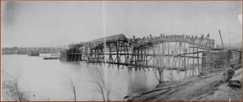
 People tend to forget that old battles, battles before mechanized cavalry, helicopters, spy satellites, and unmanned drones, were all about terrain. Old strategies involved taking the high ground, controlling mountain passes, utilizing waterways for transportation and defense, and sneaking to the enemy’s position in the gloom of the morning fog. Entire wars from ancient Thermopylae to Pacific Ocean island hopping in World War II involved strategic uses of terrain to overwhelm and defeat an enemy.
 I’m not going to recount the entirety of the battles surrounding Chickamauga and Chattanooga, there are resources out there that would do a far better job than I ever could. I will say these battles definitely revolved around the lay of the land, and actually being there brings that “eureka” moment. You can read in a book that Union soldiers raced up the slope of Lookout Mountain to chase out the Confederates, but actually going there, and seeing that side of Lookout Mountain is more of a cliff than a slope, really drives the point home that these soldiers were strong, and tough, and committed, and quite amazing. The feats these men (on both sides of the conflict) are truly mind boggling.